
Reading over the expositions that Dr. Juan Villafana Avila did, in his work “Sistemas Hidráulicos Incas (Inca Hydraulic Systems),” a conversation stood out that he had with his brother Jorge Villafana during a tour of a section of the Huirucatac Canal, where at last he said, “Brother, these works, our ancestors have left messages with deep scientific content,” and what he responds is, “You’re right, but those messages have social, economic, and political content.”
How right the Villafana brothers were in their reflections over the scientific content of the works! Upon seeing the great irrigation canal of Huirucatac, we cannot do anything but ratify a similar assertion. The line of the canal follows the configuration of the terrain, with a soft slope, that we realize is a path to follow its line and we do not get tired when we finish the tour, seeing its structure, including the works of art that the canal shows.
The social content shows itself in the constructions of its works, we can say without a doubt that the common good moved the construction of these colossal structures, which assured water for a population that depended on them. The economic content of its message we are able to understand in the best use of the territory, in the transfers that they made carrying the water to places with better conditions for climate and soil. The political message placed with manifestation in the form of the use of the territory and its resources, with respect and wisdom and the forms of adaptation to climatic processes that they surely lived, but also the understanding of the thousands of hectares that provided for its great systems, such as the waru waru, the andenes, and the irrigation system of which we are speaking.
In the past April of this year 2016, impulse by youth interested in our extraordinary Inca Hydrology, Javier Maza and his friends, we carried out a trip to the Nepeña River Basin in Ancash to do a partial tour of the Huirucatac Canal and be able to plan a project over this Pre-Inca canal.
Preparations for the trip:
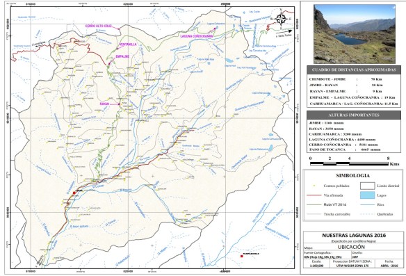
Through Facebook and the webpage Hidráulica Inca, we contacted Javier and Edmundo Paz, the first of whom is from Motocachy and the second from Jimbe. We defined dates of the trip and details of such. Javier, as a great geographic engineer of the emblematic University of San Marcos, prepared the map of the trip. Download map: Mapa – Lagunas
Participants:
- Geographical Engineer: Javier Maza
- Forestry Engineer: Vianca Meza
- Geological Engineer: Juan Martinez
- Geological Engineer: Steven Serrat
- Geological Engineer: Dany Remuzo
- Agricultural Engineer: Ronal Ancajima
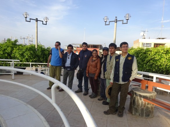
From left to right: Edmundo (Rodo), Ronald, Javier, Vianca, Juan, Dany and Steven. Square of Jimbe.
Development of Activity
Day 1: We parted from Motocachy toward Jimbe, where the integrated members of the journey were waiting on us, who were young professionals with the desire to contribute to this great irrigation system. With the delays of the trip, we left from Jimbe toward Quilcay at 7:10 AM where the truck left us and we would continue on foot. We arrived at Quilcay at 8:50 AM where we would await the arrival of our guide, Señor Fausto Jaramillo. We parted from there at approximately 10:30 AM.
Tour of the stretch, that we shall call number 1, of the Huirucatac Canal, where remains of the canal were noted in a ruined state, there were no clear signs of its existence. Route length: 5,920 m.
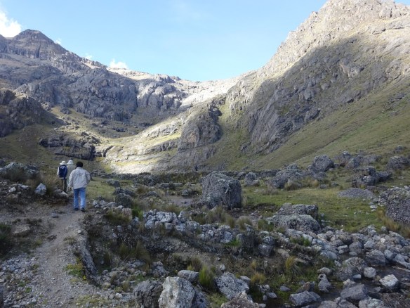
We arrived at our destiny, Quebrada Ulto Cruz, a 3:00 PM, where we “ate lunch” and prepared to set up our camp.
Some tips for carrying out a trip in our punas:
- A tent that is able to support the cold of the puna
- A sleeping bag that is enough to support the temperature of the punas
- An overnight bag with basic elements for camping
- Warm clothing: coat, facial covering, gloves, socks
- A small pickax, to clean the camp afterward
- Pills to help alleviate altitude sickness, or coca leaves
- A bottle of water
- A cellular phone that is not a smart phone of Iphone
- A pot – soup on the puna is very restorative!
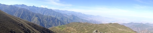
But all effort is worth it in the end after seeing such majestic mountains!
Day 2: We divided our group into 2, the first (Javier, Steven, and Juan) went to a small lagoon, Cushuro, located on the summit where we camped out and the other group (Ronald and Dany) did a tour of the canal, on a stretch of approximately 5 km. We left at 10:30 AM and arrived at our meeting place at 1:25 PM.
- Height at departure: 3,900 meters above sea level
- Height at arrival: 4,162 meters above sea level
- Length of the tour: 5,400 meters


We arrived at our meeting point with the second group, where the canal unites with the road, or better expressed the canal has been transferred into an access path towards the Lagoon Coñoc Ranra.
I am meeting place with the Second Brigade of work
Here a van comes to meet us and moved to the lagoon Conoc Ranra, we arrived at the foot of the lake at 3:15 pm, about 7 km long.
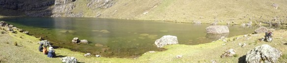
Laguna Coñoc Ranra
Conclusions:
- We covered a total of 11.32 km of the canal over 2 days of tour. In a truck approximately 7 km.
- The line of the canal is less evident in the first stretch. In the second stretch the canal shows itself in its entire splendor, with stretches that one can appreciate the slabs of the canal walls, some on foot.
- We are able to infer a canal of a rectangular section, with an approximate section averaging 60 cm at the base and 50 cm of height.
- The canal reaches the Coñoc Ranra Lagoon, where it would unite with the sections that come from the Tocanca and Capado Lagoons.
- Walking along the stretches of canal in good condition, exhaustion was minimal, which indicates soft slopes, in spite of walking on the counter slopes.
- The Huirucatac Irrigation System unites the Coñoc Ranra, Capado, Cocha, Tocanca and Huirí Lagoons with a canal of approximately 50 km (Villafana 1986). View diagram.
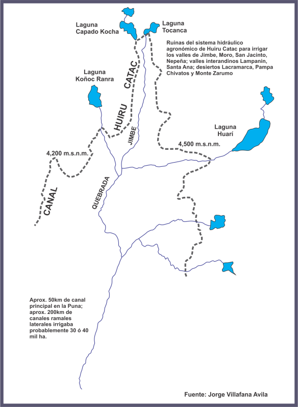
Scheme Huirucatac – Source Juan Villafana Avila
Recommendations:
- Form a research project that seeks to place value on the Irrigation System of Huirucatac.
- Find a way to involve major players of the basin, starting with the local people of the place, user organizations, representatives of institutions and leaders of the basin – that they all know the form of water management that our ancestors carried out.
- Form with the people a plan of hydrological strengthening that can be carried out in part of the basin of the Nepeña River.
- The Huirucatac Irrigation System gives us a message of scientific development that the Pre-Incas and Incas reached – in addition to social, economic, and political content.
As a contribution to this work, we share the location map of the Huirucatac Irrigation System.
